
Finish line in 2022
Keith Knipling
The Course
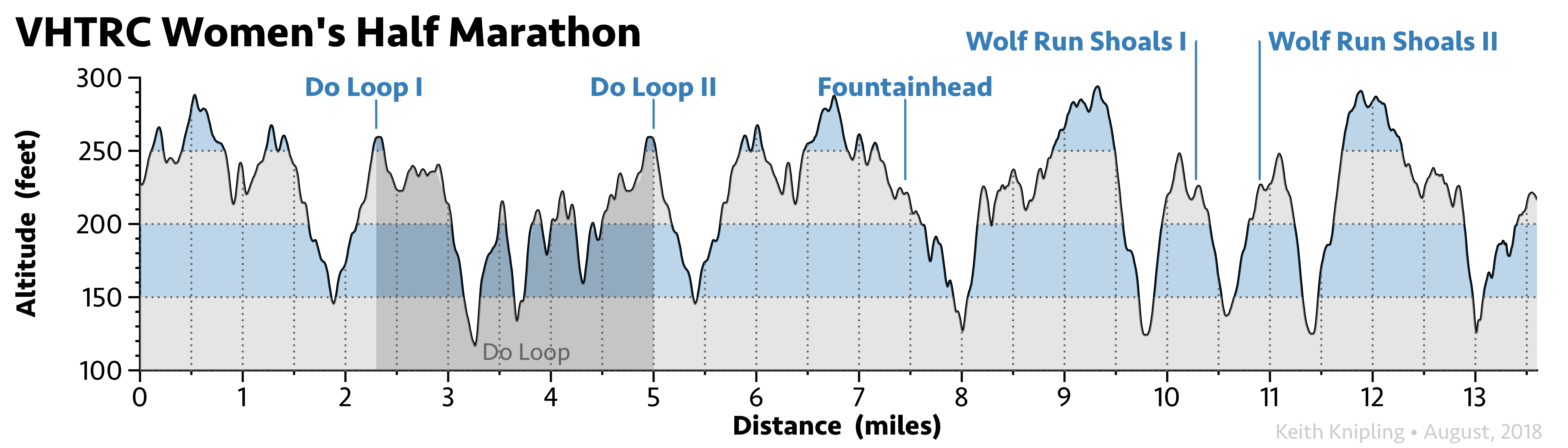
Half marathon distance
- Distance
-
- 13.6 mi
- Ascent/descent
-
- 1,600 feet
- Aid stations
-
- 5 aid stations
- Time cutoff
-
- 4 hours 30 minutes
- GPX file
This trail race winds through forested, rolling terrain in the Northern Virginia woods, almost entirely on well-traveled single-track dirt trail. There are a handful of small stream crossings. Most have footbridges, but if heavy storms hit the park just before the race, expect muddy or wet shoes. You’ll pass through aid stations with food and fluids five times, and they are never more than about 3 miles apart.
The course has changed little since 2005, although the autumn 2017 reroute of the Bull Run Occoquan Trail lengthened the second half. The race used to be a little shorter than a true 13.1-mile half marathon; now it’s a little longer. (Think of it as more bang for your buck.)
Detailed course description
The GPS track below shows the half marathon course. Its colors (blue, orange) match the trail blazes.
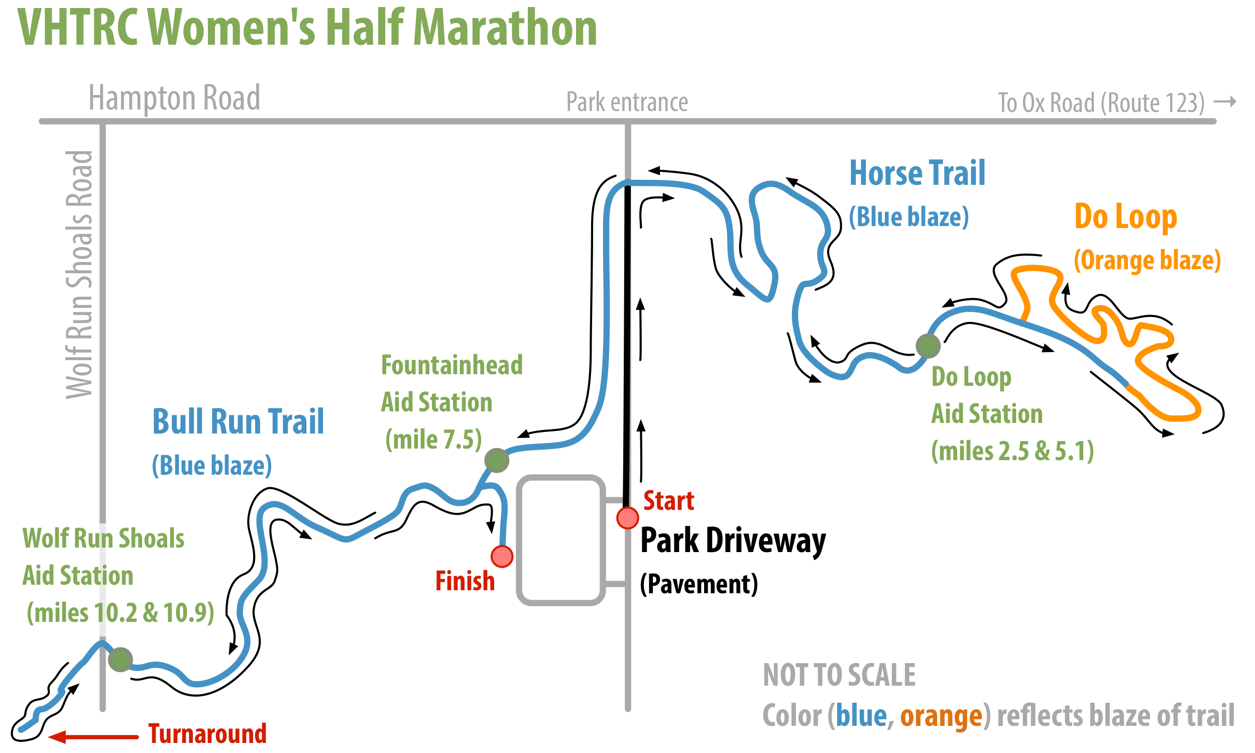
The race starts in the Fountainhead Regional Park parking lot and follows the paved park road toward the park entrance on Hampton Road. About 3/4 mile later, just before the entrance, the course turns right off the road onto a blue-blazed trail. The paved start lets the field spread out and gives you a chance to settle into a position you like.
From there, it’s rolling trail the rest of the way. A little less than 2 miles along the trail (about 2.5 miles in), you reach the first aid station, Do Loop. Just past it is the famous “Do Loop.”
The Do Loop is shaped like a lollipop on a stick. You run out along the “stick,” turn right, and run the “lollipop” counter-clockwise, with plenty of steep climbs and descents along the way. To take your mind off them, watch for the rusted-out Ford Fairlane and Nash Rambler on the loop. (Classy. We spare no expense.) Back at the “stick,” you run straight into the Do Loop Aid Station again (mile 5.1). From there, retrace your steps to the paved park road, cross it, and pick up the trail, which bears left and leads back to the parking lot and the Fountainhead Aid Station (mile 7.5).
To make sure all half marathon runners finish by 1 p.m., there is an intermediate cutoff of 10:45 a.m. at the Fountainhead Aid Station. Runners who arrive after 10:45 may not continue as official entrants.
From Fountainhead, re-enter the woods on your right on the blue-blazed Bull Run Trail and head to the Wolf Run Shoals Aid Station (mile 10.2).1 From the aid station, cross Wolf Run Shoals Road and head downhill. At about mile 10.5, cross a small stream on a bridge, turn right at the end of the bridge, recross the stream (no bridge this time), and head back; a course marshal will guide you. Then climb back up, recross Wolf Run Shoals Road, pass through the aid station once more (mile 10.9), and retrace your steps to the parking lot. At the trailhead, turn right onto the grass beside the lot, run through the marked finish chute, cross the finish line, and bask in the glory of your accomplishment.
Navigation
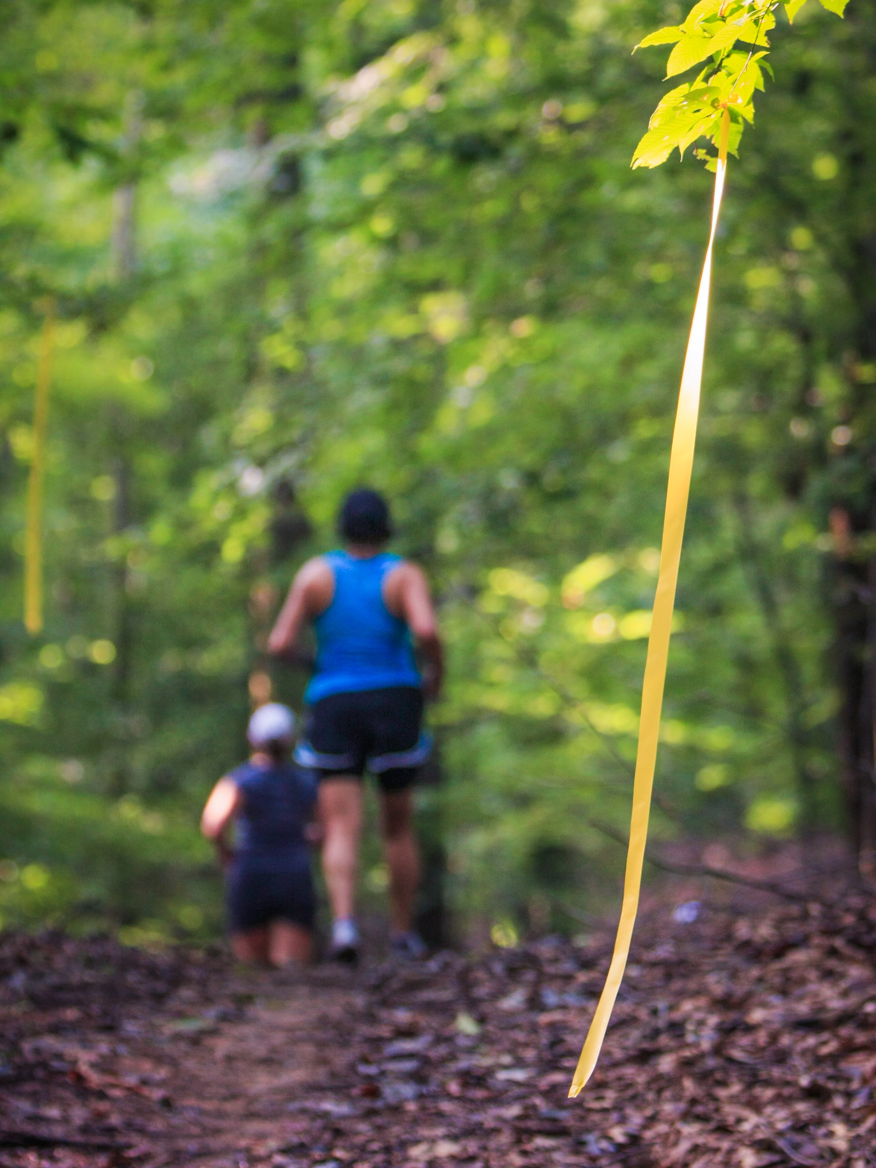
VHTRC volunteers mark the entire course with colored ribbons hung from trees. The race director will show a sample ribbon at the pre-race briefing on race morning so you know what to look for. The course is well marked, and you shouldn’t go far without seeing the next ribbon. Red ribbon laid on the ground marks places you shouldn’t go. Never step over a red ribbon!
A note on “well marked”: it means different things to road runners and trail runners. If you’re used to road races where you simply follow the herd (or the pace car, you speedster), trail running asks more of your attention. You may find yourself blissfully alone on the trail for a few minutes, and it will be up to you to stay on course. We hang ribbons at regular intervals, but don’t expect one on every other tree, and don’t panic if you haven’t seen one in 60 seconds. Keep scanning the trail ahead, and the next ribbon will turn up.
How long is the course, really?
In true trail-running spirit, we call the course “about” a half marathon. Our best measurement since the autumn 2017 reroute of the Bull Run trail is 13.6 miles. Earlier attempts produced three different answers from two GPS watches and one very old-school measuring wheel, all used on the same run. The point: your mileage may vary, especially on a GPS watch. We’re not hung up on a few tenths of a mile, and you shouldn’t be either. Trail running is slower than road running and engages more of your senses, so kick back, enjoy the scenery, listen to the birds, and stop obsessing over the exact distance. That’s the beauty of being in the woods.
Weather
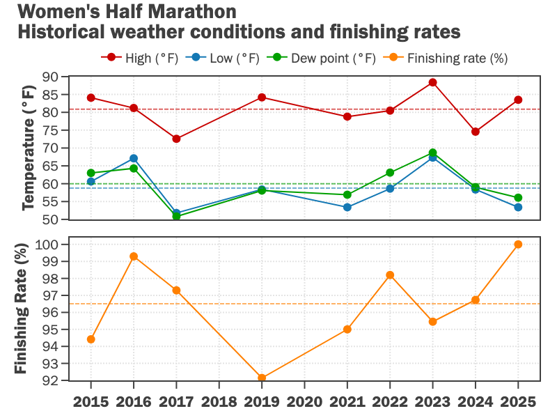
We usually have good weather for the Women’s Half, with temperatures generally in the 70s (°F).
Read the local weather forecast.
Still have questions?
See the FAQ page for details on aid station food and drink, spectators, bathrooms, and more.
The old course
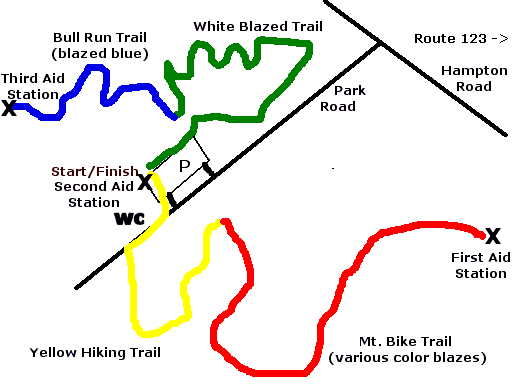
The current course dates from 2005. From 1993 through 2004, the race used the course shown here, with the same start/finish. The first out-and-back followed what are now the Fountainhead mountain bike trails (yellow and red on the map) to the present Do Loop Aid Station, then returned to the start/finish for the second aid station. From there, the route took the white-blazed trail (shown in green on the map) to the Bull Run Trail, which runners followed to a turnaround at the Wolf Run Shoals aid station (very near the present one). Runners then retraced their steps to the finish.
-
On this out-and-back section, runners heading down to the aid station will meet the front-runners coming back up. It’s tradition to encourage one another and share the trail. ↩
10K+ distance
- Distance
-
- 7.5 mi
- Aid stations
-
- 2 aid stations
Detailed course description
The 10K+ follows the first 7.5 miles of the half marathon course and finishes at Fountainhead. Its two aid stations, both at the Do Loop, split the course into nearly equal thirds of about 2.5 miles.
| Aid Station | Split | Cumulative | Map |
|---|---|---|---|
| Do Loop I | 2.5 mi | 2.5 mi | |
| Do Loop II | 2.6 mi | 5.1 mi | |
| Finish | 2.4 mi | 7.5 mi |
See the half marathon description for turn-by-turn course details, markings, weather, and more.
How long is it, really?
About 7.5 miles. Think of it as more bang for your buck: other 10Ks are only 6.2 miles!